Select location of well to view details.
Click on column heading to sort.
|
|
|
County: Barber Select location of well to view details. Click on column heading to sort. |
|
|
|
| View page: 1 || 2 || 3 || 4 || 5 || 6 || 7 || 8 || 9 || 10 || Next > | |||||||||
| T-R-S | Owner | Well Depth Ascend. Desc. |
Static Water Level Ascend. Desc. |
Est. Yield Ascend. Desc. |
Well Use | Other ID | Action Taken | Completion Date Ascend. Desc. |
Scan? |
|
T30S, R11W, Sec. 1 C NE SE |
Jacobs, Gary | 80 ft. | 60 ft. | Domestic | Constructed | 25-Sep-1991 | |||
|
T30S, R11W, Sec. 1 NE SW NE |
Kruckenburg, Bessie | 150 ft. | 35 ft. | 1600 gpm. | Irrigation | Constructed | 19-Mar-1979 | ||
|
T30S, R11W, Sec. 1 NW SE SE |
Lalicker, Pauline | 92 ft. | 45 ft. | 40 gpm. | Domestic, Livestock | Constructed | 11-Sep-2013 | ||
|
T30S, R11W, Sec. 1 SW SW SW |
Poland, Don | 82 ft. | 61 ft. | Domestic | Constructed | 03-Feb-2006 | |||
|
T30S, R11W, Sec. 1 C NE NE |
Red Tiger Drilling Co. | 155 ft. | 40 ft. | 80 gpm. | Oil Field Water Supply | Constructed | 07-May-1979 | ||
|
T30S, R11W, Sec. 2 SW NE SW |
Krukenberg, Gene | 165 ft. | 35 ft. | Irrigation | Constructed | 01-Apr-1989 | |||
|
T30S, R11W, Sec. 2 NE SE SW |
Red Tiger Drilling Co. | 152 ft. | 62 ft. | 70 gpm. | Oil Field Water Supply | Constructed | 07-Jun-1977 | ||
|
T30S, R11W, Sec. 2 NE NE SE |
Tucker Family Ag Co, LLC | 90 ft. | 55 ft. | Domestic, Livestock | Constructed | 19-Oct-2012 | |||
|
T30S, R11W, Sec. 2 SE NW SE |
Tucker, Dale | 176 ft. | 49 ft. | 1400 gpm. | Irrigation | Constructed | 18-Jul-1977 | ||
|
T30S, R11W, Sec. 2 C W2 NE |
Van Rankin, Horace | 170 ft. | 59 ft. | Irrigation | Constructed | 01-Apr-1969 | |||
|
T30S, R11W, Sec. 4 C SW SW |
Red Tiger Drilling Co. | 135 ft. | 49 ft. | 50 gpm. | Oil Field Water Supply | Constructed | 05-Aug-1977 | ||
|
T30S, R11W, Sec. 4 C NW NE |
Red Tiger Drilling Co. | 157 ft. | 60 ft. | 75 gpm. | Oil Field Water Supply | Constructed | 24-Apr-1979 | ||
|
T30S, R11W, Sec. 4 SE SW NW |
Red Tiger Drilling/Jack Crawford | 140 ft. | 45 ft. | 60 gpm. | Oil Field Water Supply | Constructed | 28-May-1982 | ||
|
T30S, R11W, Sec. 5 SW SE NW |
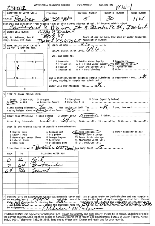
City of Isabel | 83 ft. | 64.6 ft. | Monitoring well/observation/piezometer | MW 1 | Plugged | 03-May-2000 | Scan | |
|
T30S, R11W, Sec. 5 SW SE NW |
City of Isabel | 83 ft. | 69.89 ft. | Monitoring well/observation/piezometer | MW 2 | Constructed | 14-Aug-1995 | ||
|
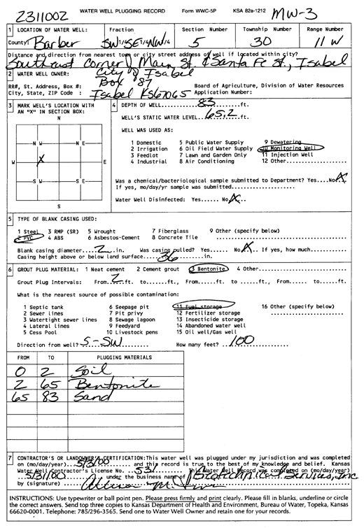
T30S, R11W, Sec. 5 SW SE NW |
City of Isabel | 83 ft. | 65.2 ft. | Monitoring well/observation/piezometer | MW 3 | Plugged | 03-May-2000 | Scan | |
|
T30S, R11W, Sec. 5 SW SE NW |
City of Isabel | 83 ft. | 71.49 ft. | Monitoring well/observation/piezometer | MW 1 | Constructed | 14-Aug-1995 | ||
|
T30S, R11W, Sec. 5 SW SE NW |
City of Isabel | 83 ft. | 70.79 ft. | Monitoring well/observation/piezometer | MW 4 | Constructed | 14-Aug-1995 | ||
|
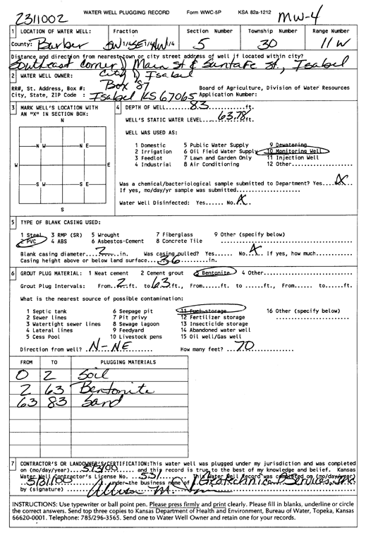
T30S, R11W, Sec. 5 SW SE NW |
City of Isabel | 83 ft. | 63.78 ft. | Monitoring well/observation/piezometer | MW 4 | Plugged | 03-May-2000 | Scan | |
|
T30S, R11W, Sec. 5 SW SE NW |
City of Isabel | 83 ft. | 72.2 ft. | Monitoring well/observation/piezometer | MW 3 | Constructed | 14-Aug-1995 | ||
|
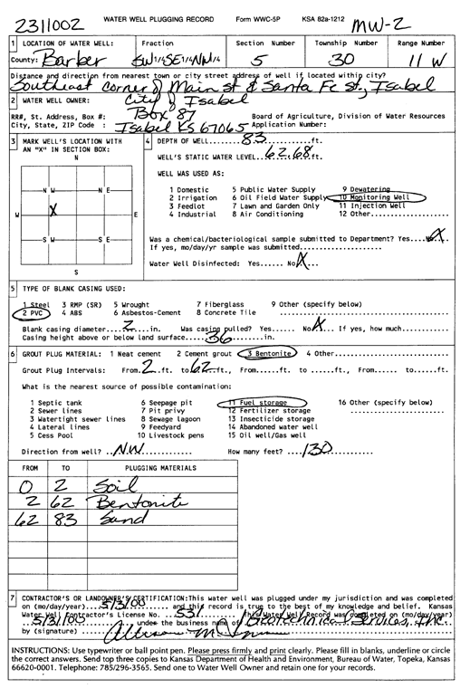
T30S, R11W, Sec. 5 SW SE NW |
City of Isabel | 83 ft. | 62.68 ft. | Monitoring well/observation/piezometer | MW 2 | Plugged | 03-May-2000 | Scan | |
|
T30S, R11W, Sec. 5 NW SW NW |
City of Isabel | 116.4 ft. | 80 ft. | Public Water Supply | BA 3 | Reconstructed | 07-Feb-2007 | ||
|
T30S, R11W, Sec. 5 NE SW NW |
Farmers Coop | 79 ft. | 51.5 ft. | Monitoring well/observation/piezometer | MW 13 | Constructed | 20-Dec-2012 | ||
|
T30S, R11W, Sec. 5 NW SW NW |
Farmers Coop | 90 ft. | 52 ft. | Dewatering | EW 1 | Constructed | 20-Dec-2012 | ||
|
T30S, R11W, Sec. 5 NW NE SE |
Farmers Coop Equity Co. | 77 ft. | 66 ft. | Monitoring well/observation/piezometer | MW 10 | Constructed | 07-May-2009 | ||
|
T30S, R11W, Sec. 5 NW NW SE |
Farmers Coop Equity Co. | 77 ft. | 66.49 ft. | Monitoring well/observation/piezometer | MW 9 | Constructed | 08-May-2009 | ||
|
T30S, R11W, Sec. 5 NW SW SE |
Farmers Coop Equity Co. | 85 ft. | 69.13 ft. | Monitoring well/observation/piezometer | MW 12 | Constructed | 07-May-2009 | ||
|
T30S, R11W, Sec. 5 NW SW NW |
Farmers Coop Equity Co. | 93 ft. | 69 ft. | Monitoring well/observation/piezometer | EW 1 | Plugged | 17-Apr-2018 | ||
|
T30S, R11W, Sec. 5 NW SW NE |
Farmers Coop Equity Co. | 81 ft. | 57 ft. | Monitoring well/observation/piezometer | MW 13 | Plugged | 17-Apr-2018 | ||
|
T30S, R11W, Sec. 5 NW SW SE |
Farmers Coop Equity Co. | 85 ft. | 75 ft. | Monitoring well/observation/piezometer | MW 12 | Plugged | 17-Apr-2018 | ||
|
T30S, R11W, Sec. 5 NW NE SE |
Farmers Coop Equity Co. | 77.5 ft. | 67.8 ft. | Monitoring well/observation/piezometer | MW 11 | Constructed | 08-May-2009 | ||
|
T30S, R11W, Sec. 5 NW SE NW |
Farmers Coop Equity Co. | 80 ft. | 68.39 ft. | Monitoring well/observation/piezometer | MW 3 | Constructed | 13-Oct-2006 | ||
|
T30S, R11W, Sec. 5 NW SE NW |
Farmers Coop Equity Co. | 122 ft. | 68.29 ft. | Monitoring well/observation/piezometer | MW 8 | Constructed | 11-Oct-2006 | ||
|
T30S, R11W, Sec. 5 NW SE NW |
Farmers Coop Equity Co. | 79.5 ft. | 66.95 ft. | Monitoring well/observation/piezometer | MW 2 | Constructed | 12-Oct-2006 | ||
|
T30S, R11W, Sec. 5 NW SE NW |
Farmers Coop Equity Co. | 80 ft. | 68.47 ft. | Monitoring well/observation/piezometer | MW 1 | Constructed | 11-Oct-2006 | ||
|
T30S, R11W, Sec. 5 NW SE NW |
Farmers Coop Equity Co. | 84.5 ft. | 69.17 ft. | Monitoring well/observation/piezometer | MW 4 | Constructed | 13-Oct-2006 | ||
|
T30S, R11W, Sec. 5 NW SE NW |
Farmers Coop Equity Co. | 35 ft. | Monitoring well/observation/piezometer | MW 7 | Constructed | 13-Oct-2006 | |||
|
T30S, R11W, Sec. 5 NW SE NW |
Farmers Coop Equity Co. | 80 ft. | 67.5 ft. | Monitoring well/observation/piezometer | MW 6 | Constructed | 13-Oct-2006 | ||
|
T30S, R11W, Sec. 5 NW SE NW |
Farmers Coop Equity Co. | 77 ft. | 66 ft. | Monitoring well/observation/piezometer | MW 5 | Constructed | 12-Oct-2006 | ||
|
T30S, R11W, Sec. 5 SE NW SW |
Gallager, John | 130 ft. | 74 ft. | 100 gpm. | Domestic | Constructed | 22-Jun-1984 | ||
|
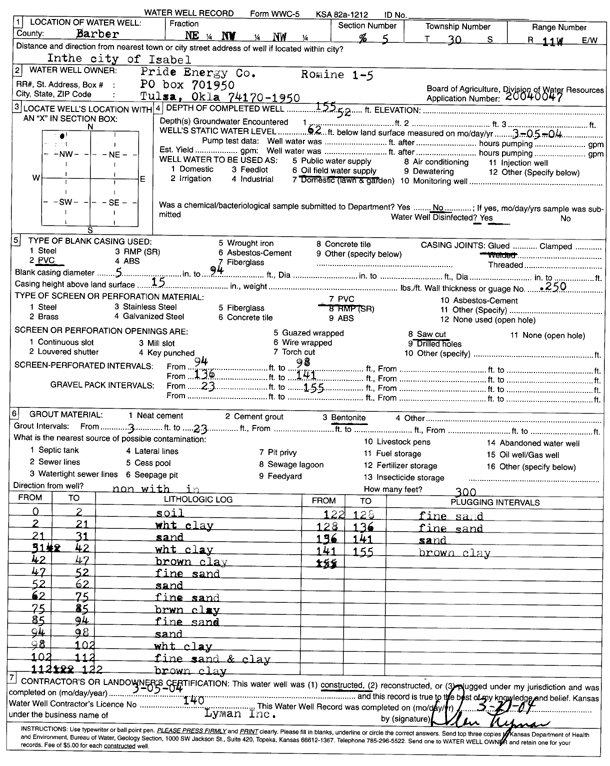
T30S, R11W, Sec. 5 NE NW NW |
Pride Energy Co. | 155 ft. | 62 ft. | Oil Field Water Supply | Romine 1-5 | Constructed | 05-Mar-2004 | Scan | |
|
T30S, R11W, Sec. 5 SE NW NE |
Union Drilling Co. | 178 ft. | 55 ft. | 50 gpm. | Oil Field Water Supply | Constructed | 29-Dec-1977 | ||
|
T30S, R11W, Sec. 6 SE NE NE |
Collie, Dennis | 102 ft. | 63 ft. | 12 gpm. | Domestic | Constructed | 14-Jan-2003 | Scan | |
|
T30S, R11W, Sec. 6 NW NW NW |
Martin, Ray and Dovie | 120 ft. | 66 ft. | Domestic | Plugged | 14-Sep-1983 | |||
|
T30S, R11W, Sec. 6 NW NW NW |
Martin, Ray and Dovie | 162 ft. | 66 ft. | 25 gpm. | Irrigation | Constructed | 08-Sep-1993 | ||
|
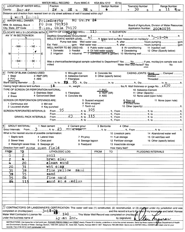
T30S, R11W, Sec. 6 SW SE NE |
Pride Energy Co. | 115 ft. | 49 ft. | Oil Field Water Supply | McGuire 2-6 | Constructed | 18-Mar-2004 | Scan | |
|
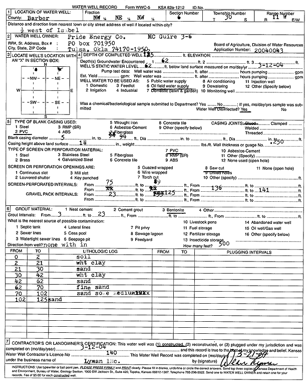
T30S, R11W, Sec. 6 NW NE NW |
Pride Energy Co. | 135 ft. | 62 ft. | Oil Field Water Supply | McGuire 3-6 | Constructed | 12-Mar-2004 | Scan | |
|
T30S, R11W, Sec. 6 SW SE SW |
Pride Energy Co. | 122 ft. | 55 ft. | Oil Field Water Supply | Hoyt 1-6 | Constructed | 28-Feb-2004 | Scan | |
|
T30S, R11W, Sec. 6 C NW NE |
Union Drilling Co. | 137 ft. | 60 ft. | 60 gpm. | Oil Field Water Supply | Constructed | 19-Jul-1978 | ||
|
T30S, R11W, Sec. 7 SE NE SW |
H-30 Drilling, Inc. | 105 ft. | 54 ft. | 80 gpm. | Oil Field Water Supply | Constructed | 16-Jul-1980 | ||
| View page: 1 || 2 || 3 || 4 || 5 || 6 || 7 || 8 || 9 || 10 || Next > | |||||||||