|
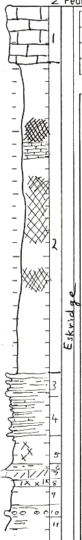
| Unit No. |
Description |
Thickness |
|
1
|
Limestone, Cottonwood - light gray, upper +/- 3 feet pitted, few, larger pits in lower part, fusulines abundant in upper part, but occur to within 1 foot at base
|
4.5 ft.
|
|
2
|
Shale, alternating bed of red and green clay
|
+/- 25 ft.
|
|
3
|
Shale, red and limestone green, limestone is more massive in upper and lower part
|
1.7 ft.
|
|
4
|
Shale and limestone, red (limestone is reddish-gray)
|
3.5 ft.
|
|
5
|
Shale, red and green, blocky
|
2.6 ft.
|
|
6
|
Shale, green, with red gypsiferous layers at top and bottom
|
0.3 ft.
|
|
7
|
Limestone, greenish gray "worm eaten"
|
0.85 ft.
|
|
8
|
Clay, red and green, blocky
|
0.55 ft.
|
|
9
|
Clay, red blocky, mottled with greenish gray at top
|
2.20 ft.
|
|
10
|
Shale, red, green limy nodules as inclusions
|
+/- 0.8 ft.
|
|
11
|
Shale, red to purple, blocky hard
|
+/- 0.8 ft.
|
|