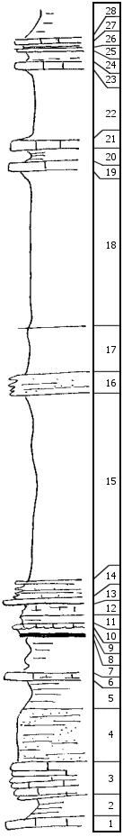
|
| Unit No. |
Description |
Thickness |
|
28
|
Gray shale
|
|
|
27
|
Limestone, nearly black
|
0.4 ft.
|
|
26
|
Dark shale, fossils
|
0.3 ft.
|
|
25
|
Gray limestone
|
0.4 ft.
|
|
24
|
Shale, many Chonetes
|
1 ft.
|
|
23
|
Light gray limestone
|
0.9 ft.
|
|
22
|
Clay shale
|
8 ft.
|
|
21
|
Massive, medium gray limestone, breaks into great blocks, crinoid stems
|
1.2 ft.
|
|
20
|
Shale
|
2 +/- ft.
|
|
19
|
Limestone, light gray, cryptozoans, Osagia
|
1.1 ft.
|
|
18
|
Shale, gray limy
|
18.6 ft.
|
|
17
|
Shale gray, crystalline geodes
|
5.5 ft.
|
|
16
|
Sandstone, platy, limonitic
|
2 +/- ft.
|
|
15
|
Shale, gray
|
2.2 ft.
|
|
14
|
Limestone and shale, thin beds, gray
|
2 ft.
|
|
13
|
Limestone, light gray, Marginifera, bryozoans
|
0.3 ft.
|
|
12
|
Shale, limy
|
1 ft.
|
|
11
|
Shale, gray, fossils
|
0.8 ft.
|
|
10
|
Limestone, nodular, fossils
|
0.4 ft.
|
|
9
|
Limonitic shale, fossils
|
0.4 ft.
|
|
8
|
Coal, trace
|
|
|
7
|
Shale, clay, limonitic
|
4 +/- ft.
|
|
6
|
Limestone, nodular, sandy, micaceous
|
2 +/- ft.
|
|
5
|
Shale, blocky, gray, limonitic at base
|
3 +/- ft.
|
|
4
|
Sandy shale, micaceous and clayey
|
5.4 ft.
|
|
3
|
Limestone, thin bedded, ferruginous
|
3 ft.
|
|
2
|
Shale
|
1 ft.
|
|
1
|
Limestone, weathers nodular
|
1.5 ft.
|
|

