|
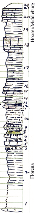
| Unit No. |
Description |
Thickness |
|
22
|
Concealed up slope to north
|
|
|
21
|
Shale - blue fissile, weathers slate gray
|
0.5 ft.
|
|
20
|
Limestone - light gray thick bedded, argillaceous, molluscan fauna, weathers buff.
|
4 ft.
|
|
19
|
Shale - light olive brown, fissile clay, exposed just West of abandonded stone service station
|
5 ft.
|
|
18
|
Limestone - light green, thick bed at base, massive toward top very porous, vertical tubes, small clams, one cephalapod, ostracoda, crinoid stems
|
3.3 ft.
|
|
17
|
Shale - greenish brown, fissile, calcareous, thin beds of soft argillaceous nodular limestone in 1 - 2 inch beds, pelecypods & brachiopods, fauna; aside from limy beds, unit above unfossilifarious
|
9.5 ft.
|
|
16
|
Shale - medium blue gray, fissile, calcareous, Bryozoa, Chonetes, Dictyoclostus, Composita, Derbya, crinoid fragments
|
2 ft.
|
|
15
|
Limestone - light gray, thick bed, 2 layers seperated by thin shale parting, this unit forms break in slope but is probably a genetis part of shale unit; contains same rich marine fauna as above & below
|
1 ft.
|
|
14
|
Shale - medium to light bluigh green, thin bed. Nodular in part large number of marine fossils; fauna similar to above but not quite so rich here
|
2.2 ft.
|
|
13
|
Limestone - light pea-green to light green, hard, argillaceous limestone or limy mudstone with pelecypods & a few brachiopods
|
0.2 ft.
|
|
12
|
Shale - dark gray, papery, calcareous, becomes drab at top
|
0.2 ft.
|
|
11
|
Limestone - lavender or pinkish, dense a single layer, weathered zone at top has a peculiar "worm" eaten appearance
|
0.4 ft.
|
|
10
|
Shale - dull green-gray. hackly thinly laminated, calcareous, weathesr to smooth round slopes; a zone 1 inch thick & 3 inches from top slightly more indurated and another 0.4 feed from top & 0.4 foot thick
|
5 ft.
|
|
9
|
Limestone - dull white, very rubbly, massive, argillaceous, weathers to a gravel like slope; bedding developed little or not at all; unfossiliferous, porous laterally into a rubbly limestone, not joining a break in the slope
|
1.7 ft.
|
|
8
|
Shale - olive green, fissile, calcareous, no fossils seen
|
0.7 ft.
|
|
7
|
Limestone - green-brown, massive, slightly more dense in lower 2/3 than unit below, but upper 1/3 characterized by presence of wavy markings (tubular, limonite coated) filled with calcite. Tubes have diameter of a pencil lead. This upper tubular limestone lies west and more argillaceous turn lower part of unit so top of ledge usually beveled & separated from next overhaning unit by a slight reentrant
|
1.4 ft.
|
|
6
|
Shale - purplish-green papery clay - forming a reentrant between the two ledges
|
0.5 ft.
|
|
5
|
Limestone - light greenish brown, massive, porous, forms a ledge; jointing well developed; large blocks weather out, contains members of small bodies which may be ostracods or algae and small clams
|
1.4 ft.
|
|
4
|
Mudstone, drab gray, slightly calcareous; lacks bedding, unfossiliferousLimestone - light brown, laminated, platy, coarsely crystalline in part argillaceous laminae due to layerettes of clay as partings and as intimate mixtures with the lime; alternating green & brown layers. Weathered surface carries great mass of chonetes, Derbya & other fossils
|
0.2 ft.
|
|
3
|
Mudstone, drab gray, slightly calcareous; lacks bedding, unfossiliferous
|
0.9 ft.
|
|
2
|
Shale - gray buff, fissile, calcareous with 3 layers each about 0.5 thick of medium blueish green shale. Rich fauna of brachiopods, (especially chonetes), crinoid fragments, bryozoa, trilobite coll., echinoids, etc.
|
12 ft.
|
|
1
|
Mostly concealed section began with highest occurance of slabs of Cottonwood limestone wearing numerous small sluender fusulines on South side of highway just west of Fox Creek siding.
|
7 ft.
|
|