|
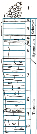
| Unit No. |
Description |
Thickness |
|
1
|
Loose chert
|
|
|
2
|
Limestone - brown-gray, crystalline, rought, fossil fragments
|
0.6 ft.
|
|
3
|
Limestone - yellowish-gray, weathers somewhat rusty, fossils silicified
|
2.5 ft.
|
|
4
|
Shale - gray, echinoid plates and spines, brachiopods; limy in lower part
|
1.8 ft.
|
|
5
|
Limestone - mottled brown and gray, weathers dark gray, crinoid fragments, Derbya
|
0.4 ft.
|
|
6
|
Shale - gray, limy with thin limestone layers and stringers, Composita, Derbya, echinoid spines and plates abundant in lower part
|
2.9 ft.
|
|
7
|
Limestone - light gray to near white; chert scattered sparsely
|
6 ft.
|
|
8
|
Limestone - white, pitted, sparse chert
|
3.1 ft.
|
|
9
|
Limestone - light gray, somewhat persistant chert zone at top, pitted, weathers rough
|
1.9 ft.
|
|
10
|
Limestone - light gray, scattered chert
|
3.3 ft.
|
|