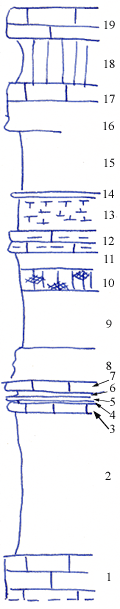
| Unit No. |
Description |
Thickness |
|
19
|
Limestone - light gray, fossiliferous
|
3 ft.
|
|
18
|
Shale - light green
|
4 ft.
|
|
17
|
Limestone - coquinoid, light gray, cavernous, with glades
|
3 ft.
|
|
16
|
Limestone - molluskan
|
1.5 ft.
|
|
15
|
Shale - bluish gray
|
5.5 ft.
|
|
14
|
Limestone - molluskan
|
0.2 ft.
|
|
13
|
Shale - bluish gray, very fossiliferous
|
2 ft.
|
|
11
|
Shale - bluish gray
|
1.5 ft.
|
|
10
|
Shale - mottled green and maroon
|
2 ft.
|
|
9
|
Shale - light gray
|
5 ft.
|
|
8
|
Shale - limy, light yellowish-gray
|
3 ft.
|
|
7
|
Limestone - light brownish gray
|
1 ft.
|
|
6
|
Shale - yellow
|
0.5 ft.
|
|
5
|
Limestone - light gray
|
0.3 ft.
|
|
4
|
Shale
|
0.2 ft.
|
|
3
|
Limestone - light gray, banded
|
0..9 ft.
|
|
2
|
Shale - dark bluish gray, light gray on top
|
13 ft.
|
|
1
|
Limestone - with numerous fusulinids (Cottonwood)
|
|