|
| Unit No. |
Description |
Thickness |
|
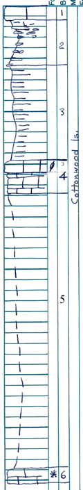
1
|
Limestone, yellow gray; weathers mottled dark gray; granular; celestite in lower part
|
1.2 ft.
|
|
2
|
Shale, (and limestone) fibrous mass; algal?; boxwork
|
4.2 ft.
|
|
3
|
Shale, blocky; gray in upper part; mostly covered
|
9 ft.
|
|
4
|
Cottonwood limestone, fusulines in upper part
|
3 ft.
|
|
5
|
Covered, (lower part of Cottonwood and upper Eskridge shale)
|
26.9 ft.
|
|
6
|
Limestone, gray; granular; porous; somewhat laminated; Osaiga
|
1 ft.
|
|