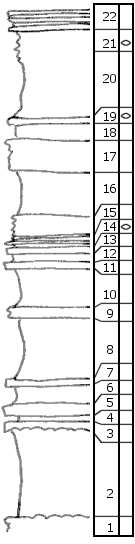
|
| Unit No. |
Description |
Thickness |
|
22
|
Limestone, flaggy, Aviculopecten, Murchisonia; little scattered chert
|
2 ft.
|
|
21
|
Shale, calc., with numerous T. venticosus
|
3 ft.
|
|
20
|
Shale, casal 0.5' calc.
|
5 ft.
|
|
19
|
Limestone, with fusulinids (few and small), Ambocoelia small crinoid joints
|
0.8 ft.
|
|
18
|
Shale
|
1.2 ft.
|
|
17
|
Limestone, flaggy; in upper 1' Aviculopecten, Myalina, Pleurophorus, in lower 2' scattered fusulinids
|
3 ft.
|
|
16
|
Shale
|
4 ft.
|
|
15
|
Shale, calc.
|
2 ft.
|
|
14
|
Shale, softer, with inflated fusulinids (sample)
|
0.5 ft.
|
|
13
|
Limestone, with shale parting; in lower part (0.4') fusulinids, Ambocoelia
|
0.9 ft.
|
|
12
|
Shale, gray
|
1.1 ft.
|
|
11
|
Limestone, massive
|
0.5 ft.
|
|
10
|
Shale, gray
|
3.5 ft.
|
|
9
|
Limestone, shaly, flaggy, Linoproductus
|
1 ft.
|
|
8
|
Shale, gray
|
5.8 ft.
|
|
|
Americus (units 7-3)
|
|
|
7
|
Limestone, with Spirifer, Myalina, Aviculopecten, bryozoans
|
0.25 ft.
|
|
6
|
Shale, gray
|
2 ft.
|
|
5
|
Limestone, mass, breaks in large slabs; large crinoid joints, Marginifera, Hustedia
|
1.1 ft.
|
|
4
|
Shale
|
0.4 ft.
|
|
3
|
Limestone, irregularly flaggy, with crinoid joints Myalina and other pelecypods. Basal part has mammillary structure with dense limestone bands
|
1 ft.
|
|
2
|
Shale, green
|
8 ft.
|
|
1
|
Boxwork (net of calcite veinlets)
|
1 ft.
|
|

