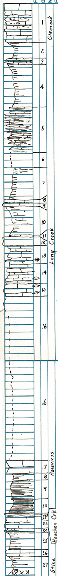
| Unit No. |
Description |
Thickness |
|
1
|
Limestone - (makes bench on which Camp Wood is built) upper part light gray and somewhat ashy; middle 3.4 feet is cavernous and contains fossil fragments; lower is massive and porous
|
5.25 ft.
|
|
2
|
Shale - gray
|
2.5 ft.
|
|
3
|
Limestone - brown, platy
|
0.8 ft.
|
|
4
|
Shale - greenish gray
|
6.1 ft.
|
|
5
|
Limestone - platy, thin beds in gray shale
|
7.35 ft.
|
|
6
|
Covered
|
2 ft.
|
|
7
|
Shale - gray
|
4.5 ft.
|
|
8
|
Limestone - medium gray and dense
|
0.4 ft.
|
|
9
|
Limestone - medium gray; granular; porous
|
0.4 ft.
|
|
10
|
Shale - light gray; limy
|
4.1 ft.
|
|
11
|
Limestone - platy
|
0.4 ft.
|
|
12
|
Limestone - yellow-gray; granular; Osagia
|
1 ft.
|
|
13
|
Limestone - yellow-gray; bedded; granular; Osagia
|
2.6 ft.
|
|
14
|
Limestone - largely covered; thin-bedded; fusulines
|
2.6 ft.
|
|
15
|
Limestone - light gray; ashy; powdery; fusulines
|
1.85 ft.
|
|
16
|
Covered
|
23.15 ft.
|
|
17
|
Limestone - (lower Americus) "horseshoe" markings; fusulines; Marginifera abundant in lower part
|
1.55 ft.
|
|
18
|
Shale - gray
|
0.75 ft.
|
|
19
|
Shale - dark gray to black; fissile
|
3.45 ft.
|
|
20
|
Shale - black; fissile
|
1.8 ft.
|
|
21
|
Limestone - impure; microfossils, ostracodes at top, algal plates lower
|
0.25 ft.
|
|
22
|
Shale - black
|
0.1 ft.
|
|
23
|
Limestone - (or calcareous siltstone) mottled darkish gray
|
1.7 ft.
|
|
24
|
Shale
|
0.45 ft.
|
|
25
|
Shale - light gray and blocky in upper few inches; remainder dark gray and less blocky
|
2.5 ft.
|
|
26
|
Limestone - gray on North side of creek; on South side a yellow clay zone
|
1.1 ft.
|
|
27
|
Shale - blocky at top, flaky below; light gray above and red in basal part; ostracodes at top
|
2.6 ft.
|