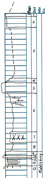
| Unit No. |
Description |
Thickness |
|
1
|
Limestone - brown gray, weathers brown; somewhat irregular, pitted top, pits are large, (snails); more or less indefinite. Contact with unit below.
|
0.6 ft.
|
|
2
|
Limestone - light gray, weathers gray; slightly crystalline; snails and many large clams, lower part somewhat more massive
|
2 ft.
|
|
3
|
Covered
|
9.85 ft.
|
|
4
|
Limestone - mottled light and dark gray; dark fossil fragments, clams abundant
|
0.9 ft.
|
|
5
|
Limestone - similar lithology to unit 4, somewhat more massive; locally slabby; clams in all but lower 0.3 ft.
|
1.95 ft.
|
|
6
|
Shale - green; hard and limy in upper part; locally upper 2 ft. weathers as limestone, lower is green clay and is sattel.
|
7.65 ft.
|
|
7
|
Clay - red
|
1.85 ft.
|
|
8
|
Shale - or clay - green, darker in lower part
|
1.7 ft.
|
|
9
|
Limestone - greenish; irregular nodular top; veins of darker green material
|
0.7 ft.
|
|
10
|
Limestone - gray "pepper and salt", suboolitic
|
0.4 ft.
|
|
11
|
Clay - green and buff
|
0.3 ft.
|
|
12
|
Shale - black
|
1.5 ft.
|
|
13
|
Limestone - black
|
0.1 ft.
|