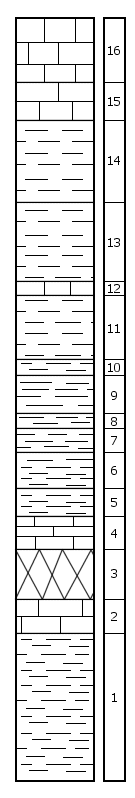
|
| Unit No. |
Description |
Thickness |
|
|
Permian System -- Council Grove Group
|
|
|
|
Funston Limestone
|
|
|
16
|
Limestone, gray, fine-grained, flaggy, no megafossils
|
5.2 ft.
|
|
15
|
Limestone, massive, gray, weathers tan, fine-grained, no megafossils
|
3.0 ft.
|
|
|
Blue Rapids Shale
|
|
|
14
|
Shale, gray, thin-bedded, weathers tan, no megafossils
|
6.1 ft.
|
|
13
|
Shale, dark gray, weathers tan, no megafossils
|
6.3 ft.
|
|
12
|
Limestone, gray, massive, no megafossils
|
1.2 ft.
|
|
11
|
Shale, red, medium-bedded, no megafossils
|
4.4 ft.
|
|
10
|
Shale, green, no megafossils
|
1.2 ft.
|
|
9
|
Shale, red, no megafossils
|
3.6 ft.
|
|
8
|
Shale, red and green, no megafossils
|
1.3 ft.
|
|
7
|
Shale, green, no megafossils
|
1.1 ft.
|
|
6
|
Shale, olive drab and red, thin-bedded, no megafossils
|
1.2 ft.
|
|
5
|
Shale, red, thin-bedded, no megafossils
|
3.2 ft.
|
|
|
Crouse Limestone
|
|
|
4
|
Limestone, light gray, massive, bone fragments
|
4.2 ft.
|
|
3
|
Covered interval
|
4.5 ft.
|
|
2
|
Limestone, light gray, massive, bone fragments, crinoid columnals
|
2.9 ft.
|
|
|
Easly Creek Shale
|
|
|
1
|
Shale, light to dark gray, weathers light gray, no megafossils
|
11.2 ft.
|
|
|
Total thickness of section
|
56.1 ft.
|
|

