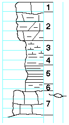
KGS Home

Geology Index Page

Marshall County

Sec. 21, T. 4 S., R. 9 E
Move to another county

1/2 mile south of Frankfort, on K-99
Modified from section measured by Elias, 1932, by O'Connor and Jewett, 1952
Unit No. Description Thickness
  HOWE LIMESTONE MEMBER  
1 Limestone, dolomite, buff to yellow, impure, cavernous, weathers rough, spongy with network of calcite and quartz veinlets and brownish ochre between veinlets. Fossils not identifiable. 1.0 ft.
2 Limestone, dolomite, shaley, to chalky, soft, splittery, buff 3 ft.
  BENNETT SHALE MEMBER  
3 Shale, calcareous, gray 1.5 ft.
4 Shale, dark gray, contains Orbiculoides 1.0 ft.
5 Shale, black, fissile 2.0 ft.
6 Shale, gray 0.7 ft.
  GLENROCK LIMESTONE MEMBER  
7 Limestone, hard yellowish tan, upper part contains abundant fusulinids, lower part contains foraminifera, ostracodes, gastropods, bryozoans, and other shell fragments, calcareous algae 2.5 ft.

Original Document

The Archive file you download contains a TIFF image compressed into a ZIP archive. Your browser may be already set up to decompress these files. Commercial software to perform this is available from PKWARE, Inc., the company that invented the format. A web page from a group of people creating shareware or public domain software is available at Info-ZIP. The TIFFs are 150-dpi archival-quality color scans of the original forms and can be viewed by software like Corel PhotoPaint or Adobe PhotoShop. To read the PDF version, you will need the Acrobat PDF Reader, available free from Adobe.


Kansas Geological Survey
Comments to webadmin@kgs.ku.edu
URL=http://www.kgs.ku.edu/General/Geology/Measured/index.html
Programs Updated May 2003