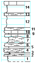
|
| Unit No. |
Description |
Thickness |
|
|
Neva limestone member
|
|
|
14
|
Limestone, light-gray, tough, fossiliferous
|
1 ft.
|
|
--
|
Shale, gray
|
3 ft.
|
|
13
|
Mudstone, greenish-gray
|
1 ft.
|
|
12
|
Shale, gray
|
4 ft.
|
|
11
|
Limestone, flaggy, cavernous, light-gray with microfauna
|
1 ft.
|
|
10
|
Limestone, light-gray
|
1 ft.
|
|
9
|
Shale
|
0.2 ft.
|
|
8
|
Limestone, light-gray
|
1 ft.
|
|
7
|
Shale, gray to black and fissile at base
|
2 ft.
|
|
6
|
Mudstone, dark-gray with fauna in the upper part: Juresania, Myalina, Aviculopecten, Spirifer, crinoid joints, Stiliola-like cylindrical shells
|
1 ft.
|
|
5
|
Shale, calcareous
|
0.5 ft.
|
|
4
|
Mudstone to limestone, with small crinoid joints in the upper part
|
1.5 ft.
|
|
3
|
Shale, calcareous, splittery
|
0.5 ft.
|
|
2
|
Mudstone to limestone
|
0.8 ft.
|
|
1
|
Shale, calcareous in lower part
|
2+ ft.
|
|

