|
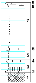
| Unit No. |
Description |
Thickness |
|
|
Herington limestone (erosional remnant on the top of the mound)
|
|
|
9
|
Mudstone, light-gray
|
0.5 ft.
|
|
8
|
Mudstone, splittery, with Derbyia and Bellerophon (?)
|
0.5 ft.
|
|
|
Paddock shale member
|
|
|
7
|
Covered
|
14 ft.
|
|
|
Krider limestone member
|
|
|
6
|
Mudstone, with Myalina and Composita
|
0.6 ft.
|
|
5
|
Covered
|
3.4 ft.
|
|
4
|
Limestone
|
0.5 ft.
|
|
|
Odell shale formation
|
|
|
3
|
Shale, green
|
3 ft.
|
|
2
|
Limestone, with Pseudomonotis hawnii, Aviculopecten and Schizodus
|
0.5 ft.
|
|
1
|
Shale, red
|
3 ft.
|
|

