KGS Home

Geology Index Page

Wabaunsee County

Sec. 28, T. 11 S., R. 10 E
Move to another county

Interstate 70 roadcut on north side of road, 1.4 miles west of Kansas Highway 99 overpass
Measured By Barry Perlmutter, June 1970
Unit No. Description Thickness
  Permian System  
  Wreford Limestone -- Chase Group  
  Three Mile Limestone Member  
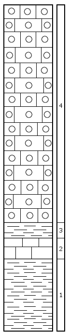
4 Limestone, gray, massive, chert nodules 30.0 + ft.
3 Shale, dark gray, massive, crinoid columnals, other shell hash 2.1 ft.
2 Limestone, light gray to tan, massive, ostracodes present 3.2 ft.
1 Shale, dark gray, thin-bedded, no megafossils, base covered 10.8 ft.
  Total thickness of section 46.1 + ft.

Original Document

The Archive file you download contains a TIFF image compressed into a ZIP archive. Your browser may be already set up to decompress these files. Commercial software to perform this is available from PKWARE, Inc., the company that invented the format. A web page from a group of people creating shareware or public domain software is available at Info-ZIP. The TIFFs are 150-dpi archival-quality color scans of the original forms and can be viewed by software like Corel PhotoPaint or Adobe PhotoShop.


Kansas Geological Survey
Comments to webadmin@kgs.ku.edu
URL=http://www.kgs.ku.edu/General/Geology/Measured/index.html
Programs Updated May 2003