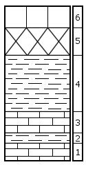
KGS Home

Geology Index Page

Wabaunsee County

Sec. 28, T. 11 S., R. 10 E
Move to another county

Interstate 70 roadcut on north and south sides of road, 0.9 miles west of Kansas Highway 99 overpass
Measured By Barry Perlmutter, July 1970
Unit No. Description Thickness
  Permian System -- Council Grove Group  
  Bader Limestone  
  Middleburg Limestone Member  
6 Limestone, massive, tan, no megafossils 2.1 ft.
  Hooser Shale Member  
5 Covered interval 3.0 ft.
4 Shale, red and green, thin-bedded, no megafossils 5.4 ft.
  Eiss Limestone Member  
3 Limestone, tan, massive, no megafossils 2.2 ft.
2 Siltstone, gray to tan, calcareous, no megafossils 1.1 ft.
1 Limestone, tan, massive, no megafossils 2.3 ft.
  Total thickness of section 16.1 ft.

Original Document

The Archive file you download contains a TIFF image compressed into a ZIP archive. Your browser may be already set up to decompress these files. Commercial software to perform this is available from PKWARE, Inc., the company that invented the format. A web page from a group of people creating shareware or public domain software is available at Info-ZIP. The TIFFs are 150-dpi archival-quality color scans of the original forms and can be viewed by software like Corel PhotoPaint or Adobe PhotoShop.


Kansas Geological Survey
Comments to webadmin@kgs.ku.edu
URL=http://www.kgs.ku.edu/General/Geology/Measured/index.html
Programs Updated May 2003