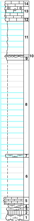
|
| Unit No. |
Description |
Thickness |
|
|
Luta limestone member
|
|
|
14
|
Limestone, crystalline, fossiliferous, softer near the base
|
2 ft.
|
|
|
Cresswell limestone member
|
|
|
13
|
Limestone, with geodes at the top, softer toward the base
|
4 ft.
|
|
12
|
Limestone, yellowish green-gray, crystalline
|
1 ft.
|
|
|
Grant shale member
|
|
|
11
|
Shale
|
12 ft.
|
|
|
Stoval limestone member
|
|
|
10
|
Limestone, largely replaced by flint
|
0.8 ft.
|
|
|
Gage shale formation
|
|
|
9
|
Shale
|
1 ft.
|
|
8
|
Covered
|
33 ft.
|
|
7
|
Limestone, crystalline, greenish-gray
|
1 ft.
|
|
6
|
Covered
|
14 ft.
|
|
|
Towanda limestone formation
|
|
|
5
|
Limestone, flaggy, green, banded, with small pelecypods (Pleurophorus?)
|
2.7 ft.
|
|
4
|
Shale
|
1 ft.
|
|
3
|
"Box work," green
|
1 ft.
|
|
2
|
Shale, green
|
1.5 ft.
|
|
1
|
"Box work," green
|
2 ft.
|
|
