|
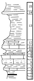
| Unit No. |
Description |
Thickness |
|
15
|
Shale, gray brown, crumbly clay, Linoproductus
|
3 ft.
|
|
14
|
Limestone, blh, fine
|
0.4 ft.
|
|
13
|
Shale, gray clay
|
7 ft.
|
|
12
|
Limestone, light gray, shaly soft, makes weak bench
|
1.2 ft.
|
|
11
|
Limestone, light gray, nearly white, massive, fine grained, earthy, vertical joints, weathers in slabs; unfossiliferous
|
1 ft.
|
|
10
|
Shale, gray, clay to calcareous, with brown boxwork of veins in lower part
|
1.2 ft.
|
|
9
|
Limestone, gray, fine-grained, fragmental
|
0.15 ft.
|
|
8
|
Shale yellow brown clay
|
0.15 ft.
|
|
7
|
Limestone, brown, massive, irregular, fine-grained, contains abundant Chonetes and bryozoans
|
1 ft.
|
|
6
|
Siltstone, calcareous, lt bl, massive, hd
|
1.2 ft.
|
|
5
|
Shale bl, clay, abundant fossils include brachiopods and crinoid fragments
|
1 ft.
|
|
4
|
Limestone, lt bl, earthy, fossiliferous, soft, contains Chonetes, Juresania, and fusulinids
|
0.5 ft.
|
|
3
|
Shale, bl cl, has Chonetes, granulifer and Linoproductus
|
1.2 ft.
|
|
2
|
Coal, blocky, fair grade
|
0.2 ft.
|
|
1
|
Shale, dk bl, silty
|
exp. 1 ft.
|
|

