|
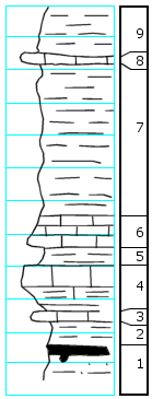
| Unit No. |
Description |
Thickness |
|
9
|
Shale
|
3+ ft.
|
|
8
|
Limestone, gray, very fossiliferous, crinoids, brachiopods, bryozoans
|
0.5 ft.
|
|
7
|
Shale, laminated, weathers fissile
|
9.0 ft.
|
|
6
|
Limestone, grading up into shale, laminated, argillaceous; no fossils seen
|
1.2 ft.
|
|
5
|
Shale, olive-brown, clay
|
1.0 ft.
|
|
4
|
Shale, grading imperceptibly up into limestone; very fossiliferous. Large Chonetes, large crinoid stems (elliptical and round). Dictyoclostus, Lophophyllum, Derbya (small) is esp. (a) in the limestone, a thin zone of very fossiliferous limestone overlies this unit, with small crinoid stems and other dwarfed shells
|
2.5 ft.
|
|
3
|
Limestone (Five Point), gray, argillaceous with fusulines, crinoids, Rhombopora, Chonetes, Ambocoelia
|
0.4 ft.
|
|
2
|
Shale, gray with Chonetes, Linoproductus, Neospirifer, Hustedia, crinoid remains, Composita
|
1.0 ft.
|
|
1
|
Coal with gray sandstone, shale below
|
0.6 ft.
|
|

