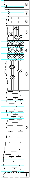
KGS Home

Geology Index Page

Marshall County

Sec. 33, T. 3 S., R. 6 E
Move to another county

SE 1/4 sect. 33
Measured By M.K. Elias, 1932.
Remarks IV-8
Unit No. Description Thickness
  Towanda limestone formation  
8 Limestone, flaggy, fine-banded, light-gray to light-buff (much slumped) 3 ft.
7 Shale, light-gray 2.5 ft.
6 Limestone, crystalline, banded 3 ft.
  Holmesville shale formation  
5 Shale, calcareous, greenish with some red spots 5 ft.
4 Shale, red, with few thin green bands 7 ft.
3 Shale, greenish, with some red spots, somewhat calcareous in upper part 10 ft.
2 Shale, calcareous, to mudstone 28 ft.
1 Limestone with flint bands  

Original Document

The Archive file you download contains a TIFF image compressed into a ZIP archive. Your browser may be already set up to decompress these files. Commercial software to perform this is available from PKWARE, Inc., the company that invented the format. A web page from a group of people creating shareware or public domain software is available at Info-ZIP. The TIFFs are 150-dpi archival-quality color scans of the original forms and can be viewed by software like Corel PhotoPaint or Adobe PhotoShop. To read the PDF version, you will need the Acrobat PDF Reader, available free from Adobe.


Kansas Geological Survey
Comments to webadmin@kgs.ku.edu
URL=http://www.kgs.ku.edu/General/Geology/Measured/index.html
Programs Updated May 2003