|
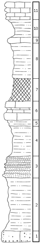
| Unit No. |
Description |
Thickness |
|
11
|
Limestone (Aspinwall), tan to yellow on fresh surface, weathers gray to tan, thin- to thick-bedded, impure, conglomeratic in places; covered interval of 2 feet above with calcareous shale and limestone conglomerate
|
3 ft.
|
|
10
|
Siltstone (Towle), tan, not bedded, shaly; unfossiliferous
|
3 ft.
|
|
9
|
Limestone (Towle), light gray on both fresh and weathered surfaces, massive; unfossiliferous
|
1 ft.
|
|
8
|
Siltstone (Towle), tan, not bedded, shaly; unfossiliferous
|
6 ft.
|
|
7
|
Shale (Towle), red, not bedded, weathers blocky, silty and hard; unfossiliferous
|
4 ft.
|
|
6
|
Limestone (Brownville), gray-green on fresh surface, stained reddish brown on weathered surface, discontinuously thick-bedded, highly impure, silty limestone; scattered brachiopods including Marginifera, bryozoans, crinoid remains, pelecypods, and sparse fusulinids
|
3 ft.
|
|
5
|
Shale (Pony Creek), red and green, not bedded, silty and hard; abundant minute fossil fragments, pelecypods, brachiopods, and bryozoans
|
0.7 ft.
|
|
4
|
Shale (Pony Creek), tan on both fresh and weathered surfaces, indistinct bedding, silty to clayey
|
5 ft.
|
|
3
|
Sandstone (Pony Creek), brown on both fresh and weathered surfaces, platy-bedded; unfossiliferous; changes facies eastward to lithology like that of underlying unit (seen only at western end of exposure)
|
4 ft.
|
|
2
|
Shale (Pony Creek), gray on fresh surface, weathers tan; flaky-bedded, silty; barren of megascopic fossils
|
9.2 ft.
|
|
1
|
Limestone (Pony Creek), gray-blue on fresh surface, weathers brown, massive-bedded, conglomerate with sub-rounded limestone, clay, and limonite pebbles less than 0.1 foot in longest dimension, extremely compact; sparse minute fossil fragments
|
2 ft.
|
|
