KGS Home

Geology Index Page

Wabaunsee County

Sec. 29, T. 11 S., R. 12 E
Move to another county

Near SE cor. sec. 29, T. 11 S., R. 12 E. Road cut.
Measured By Swain, August 29, 1940
Unit No. Description Thickness
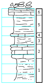
- Fragments of very fossiliferous crinoidal limestone above; huge crinoid stems  
6 Limestone, light gray, weathers brown, platy, laminated, mud-cracked, cracks filled with sand 1.5 ft.
5 Shale, olive-brown 4.0 ft.
4 Limestone algal? or conglomeratic (sample) 0.1 ft.
3 Shale, brown 2.0 ft.
2 Limestone, brown, very rubbly, Marginifera, crinoids, Ambocoelia, Rhombopora 3.0 ft.
1 Sandstone, shale, buff, micaceous 4.5 ft.

Original Document

The Archive file you download contains a TIFF image compressed into a ZIP archive. Your browser may be already set up to decompress these files. Commercial software to perform this is available from PKWARE, Inc., the company that invented the format. A web page from a group of people creating shareware or public domain software is available at Info-ZIP. The TIFFs are 150-dpi archival-quality color scans of the original forms and can be viewed by software like Corel PhotoPaint or Adobe PhotoShop.


Kansas Geological Survey
Comments to webadmin@kgs.ku.edu
URL=http://www.kgs.ku.edu/General/Geology/Measured/index.html
Programs Updated May 2003