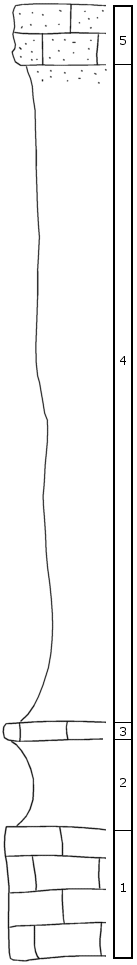
KGS Home

Geology Index Page

Wabaunsee County

Sec. 18, T. 11 S., R. 13 E
Move to another county

East of Maple Hill
Measured By R.C. Moore
(Not dated)
Unit No. Description Thickness
5 S shale and sandstone, light blue-gray, yellow-brown bench, cryptozoa abundant. Fusulina, crinoid stems, etc.  
4 Shale, red zone near center  
- Combined thickness of units 4-5 48 ft.
3 Limestone, blue hd mass, single bed, crinoid fragments, few small fusulinids 1 ft.
2 Shale, carbonaceous, with sandy streaks; no fossils seen 4 ft.
1 Limestone (Tarkio), massive, brown 9 ft.

Original Document

The Archive file you download contains a TIFF image compressed into a ZIP archive. Your browser may be already set up to decompress these files. Commercial software to perform this is available from PKWARE, Inc., the company that invented the format. A web page from a group of people creating shareware or public domain software is available at Info-ZIP. The TIFFs are 150-dpi archival-quality color scans of the original forms and can be viewed by software like Corel PhotoPaint or Adobe PhotoShop.


Kansas Geological Survey
Comments to webadmin@kgs.ku.edu
URL=http://www.kgs.ku.edu/General/Geology/Measured/index.html
Programs Updated May 2003