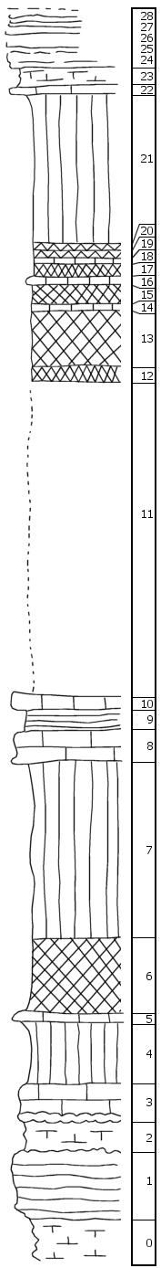
|
| Unit No. |
Description |
Thickness |
|
28
|
Flint in numerous bands
|
|
|
27
|
Limestone with heavy flint band at base
|
1 ft.
|
|
26
|
Limestone with red band of flint in the middle
|
1 ft.
|
|
25
|
Limestone with thin band of flint in upper part and 0.3' flint band at base
|
0.8 ft.
|
|
24
|
Limestone with two thin flint bands
|
0.5 ft.
|
|
23
|
Shale, calcareous
|
1.5 ft.
|
|
22
|
Limestone, shaly
|
0.5 ft.
|
|
21
|
Shale, green
|
11 ft.
|
|
20
|
Shale, purple
|
0.5 ft.
|
|
19
|
Shale, red
|
0.5 ft.
|
|
18
|
Shale, green
|
0.5 ft.
|
|
17
|
Shale, red
|
1 ft.
|
|
16
|
Shale, calcareous, green
|
0.5 ft.
|
|
15
|
Shale, red
|
1.5 ft.
|
|
14
|
Shale, green
|
0.5 ft.
|
|
13
|
Shale, red
|
4 ft.
|
|
12
|
Shale, purple and greenish-blue
|
1 ft.
|
|
11
|
Covered, mostly shale (?)
|
23 ft.
|
|
10
|
Limestone, tough, massive, with scattered small crinoid joints
|
1 ft.
|
|
9
|
Shale, gray
|
1.5 ft.
|
|
8
|
Limestone, tough, massive, with scattered small crinoid joints
|
2.5 ft.
|
|
7
|
Shale, green (cavernous zone 0.5', 0.5' above the base)
|
15.5 ft.
|
|
6
|
Shale, maroon, purple on top
|
5.5 ft.
|
|
5
|
Limestone, light gray
|
0.5 ft.
|
|
4
|
Shale, green
|
4.5 ft.
|
|
3
|
Limestone, massive, coquinoid (?), flint band at base
|
3 ft.
|
|
2
|
Shale, calcareous
|
2 ft.
|
|
1
|
Limestone with numerous flint bands
|
5 ft.
|
|
0
|
Shale, calcareous, hard
|
|
|

