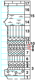
|
| Unit No. |
Description |
Thickness |
|
|
Kinney limestone formation
|
|
|
17
|
Limestone, dense, fossiliferous
|
1.5 ft.
|
|
16
|
Shale, greenish, with fine sandy bands
|
3 ft.
|
|
15
|
Shale, calcareous
|
1 ft.
|
|
14
|
Shale, calcareous to splittery mudstone, with bands of fine soft conglomerate (made of small shale and calcareous pebbles)
|
3 ft.
|
|
|
Wymore shale member
|
|
|
13
|
Shale, green
|
4 ft.
|
|
12
|
Shale, purple
|
1 ft.
|
|
11
|
Shale, brick-red
|
1.5 ft.
|
|
10
|
Shale, purple
|
0.2 ft.
|
|
9
|
Shale, green
|
0.5 ft.
|
|
8
|
Shale, maroon
|
0.3 ft.
|
|
7
|
Shale, brick-red
|
2.5 ft.
|
|
6
|
Shale, green
|
2 ft.
|
|
5
|
Shale, maroon
|
1 ft.
|
|
4
|
Shale, brick-red
|
1 ft.
|
|
3
|
Shale, green
|
0.5 ft.
|
|
2
|
Limestone, green, massive, with quartz geodes near the top. Full of fragmentary and small fossils. Murchisonia and small Aviculopecten
|
2 ft.
|
|
1
|
Shale, green
|
1 ft.
|
|

