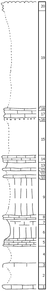
|
| Unit No. |
Description |
Thickness |
|
|
Threemile
|
|
|
20
|
Flint top bench of Threemile Limestone
|
2 +/- ft.
|
|
|
Speiser
|
|
|
19
|
Covered
|
23 ft.
|
|
|
Funston
|
|
|
18
|
Limestone with small algal nodules
|
0.3 ft.
|
|
17
|
Limestone, somewhat flaggy, with Murchissonia and small pelecypods
|
1.7 ft.
|
|
16
|
Limestone, shaly at the base, with Aviculopecten, Myalina and algal bisquits
|
0.5 ft.
|
|
15
|
Covered
|
8 ft.
|
|
14
|
Limestone, flaggy, coquinoid; Juresania and bryozoa at the top
|
1.5 ft.
|
|
13
|
Covered
|
1.5 ft.
|
|
12
|
Limestone, tough, laminated, with short and thin vertical canals
|
0.5 ft.
|
|
11
|
Covered
|
1 ft.
|
|
|
Blue Rapids
|
|
|
10
|
Limestone with small and medium sized algal bisquits
|
0.5 ft.
|
|
9
|
Covered, mostly greenish-gray shale
|
9 ft.
|
|
8
|
Limestone, platy
|
0.5 ft.
|
|
7
|
Shale, calcareous and platy
|
0.5 ft.
|
|
6
|
Shale, bright green
|
4.5 ft.
|
|
|
Crouse
|
|
|
5
|
Limestone, platy
|
2 ft.
|
|
4
|
Covered
|
4 ft.
|
|
3
|
Limestone
|
0.5 +/- ft.
|
|
2
|
Covered
|
4.5 ft.
|
|
1
|
Limestone, tough, cavernous, with small gastropods and pelecypods
|
1 +/- ft.
|
|

