|
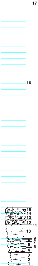
| Unit No. |
Description |
Thickness |
|
17
|
Base Florence flint
|
|
|
16
|
Covered
|
66 ft.
|
|
|
Schroyer limestone
|
|
|
15
|
Limestone, massive, almost entirely replaced by flint, with quartz geodes
|
1.5 ft.
|
|
14
|
Limestone, shaly, splittery, with quartz geodes
|
1 ft.
|
|
13
|
Limestone, massive, with one think band of flint and fossils: Dictyoclostus, large Derbyia, Chonetes, large Myalina, crinoid joints, Bryozoa
|
1.5 ft.
|
|
12
|
Flint
|
1.5 ft.
|
|
11
|
Shale, with Composita, Dictyclastus, Pinna, Myalina
|
0.5 ft.
|
|
10
|
Mudstone, massive, with small quartz geodes, and scattered Composita and a few small Myalina
|
4 ft.
|
|
9
|
Shale, calcareous
|
0.2 ft.
|
|
8
|
Mudstone, with small pebbles and Aviculopecten
|
0.5 ft.
|
|
7
|
Shale
|
0.3 ft.
|
|
6
|
Mudstone
|
0.8 ft.
|
|
5
|
Shale
|
0.3 ft.
|
|
4
|
Mudstone, somewhat cavernous, flaggy, few small Aviculopecten near the base
|
1.5 ft.
|
|
3
|
Shale, gray, splittery
|
1.5 ft.
|
|
2
|
Shale, blue-gray
|
1.5 ft.
|
|
1
|
Shale, calcareous, flaggy
|
1 ft.
|
|

