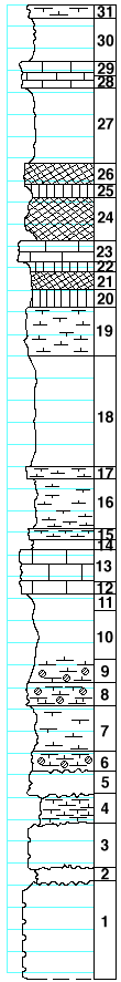
|
| Unit No. |
Description |
Thickness |
|
|
Towanda limestone formation
|
|
|
31
|
Limestone, soft, very porus, bedded, resembling coquina
|
1 ft.
|
|
30
|
Shale
|
3.2 ft.
|
|
29
|
Limestone, tough, gray
|
1 ft.
|
|
28
|
Mudstone, cavernous, yellowish
|
1 ft.
|
|
27
|
Shale, yellowish-gray
|
7 ft.
|
|
|
Holmesville sh formation
|
|
|
26
|
Shale, calcareous, splittery, maroon
|
2 ft.
|
|
25
|
Shale, green
|
1.2 ft.
|
|
24
|
Shale, calcareous to mudstone near the base, maroon
|
4 ft.
|
|
23
|
Limestone, crystalline, yellowish-gray, tough, cavernous
|
2 ft.
|
|
22
|
hale, yellowish-green
|
1 ft.
|
|
21
|
Shale, maroon
|
1.5 ft.
|
|
20
|
Shale, yellowish-green
|
1.8 ft.
|
|
19
|
Limestone, crystalline, very cavernous, yellow
|
4.3 ft.
|
|
18
|
Shale, calcareous to very soft mudstone
|
10 ft.
|
|
17
|
Mudstone, yellow-gray, with numerous pelecypods (Pleurophorus?)
|
1 ft.
|
|
16
|
Shale, calcareous to very soft mudstone
|
4.5 ft.
|
|
15
|
Mudstone with few pelecypods (Pleurophorus?)
|
1 ft.
|
|
14
|
Shale, calcareous
|
1 ft.
|
|
|
Fort Riley ls member
|
|
|
13
|
Mudstone, massive, porus, yellowish, with Derbyia, crinoid joints, echinoid remains
|
3 ft.
|
|
12
|
Mudstone, gray, cavernous
|
1 ft.
|
|
|
Oketo sh member
|
|
|
11
|
Shale, calcareous, with Derbyia, Aviculopecten and other poorly preserved pelecypods
|
1.5 ft.
|
|
10
|
Shale, blueish-gray
|
4.5 ft.
|
|
9
|
Shale to splittery mudstone at the base, quartz geodes in the lower part
|
2 ft.
|
|
8
|
Mudstone with quartz geodes
|
2 ft.
|
|
7
|
Shale, blueish-gray
|
4 ft.
|
|
|
Florence ls member
|
|
|
6
|
Mudstone with quartz geodes
|
2 ft.
|
|
5
|
Limestone, largely replaced by flint
|
2 ft.
|
|
4
|
Shale, calcareous
|
3 ft.
|
|
3
|
Limestone, largely replaced by flint
|
4 ft.
|
|
2
|
Shale, calcareous, with quartz geodes
|
1 ft.
|
|
1
|
Limestone, largely, replaced by flint
|
9 ft.
|
|

