|
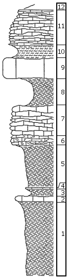
| Unit No. |
Description |
Thickness |
|
|
Americus Limstone Member
|
|
|
12
|
Covered
|
|
|
11
|
Friable, brachiopod wackestone, gray to white, with abundant brachiopod fragments and spines and whole Neospirifer and Dictyoclostus brachiopods, common echinoid spines, few ostracodes and Globivalvulina forams, and very rare trilobite fragments, wavy bedded. Abundant Chonetes and few Composita brachiopods occur near base
|
0.52 m
|
|
10
|
Blocky shale
|
0.2 m
|
|
9
|
Crinoid wackestone, gray, with many brachiopods
|
0.31 m
|
|
8
|
Shale, gray to tan, fissile
|
0.4 m
|
|
7
|
Foram wackestone, gray to white, with abundant loose and encrusting Calcivertella forams, common Globivalvulina and "Hobsonites-Z" forams and ostracodes, many whole and fragmented pectinoid and myalinid bivalves, foram-algal-coated intraclasts of peloid, alga boundstone, about 1 mm thick by 5 mm long, crinoid fragments... [Continued. See archive file for complete description]
|
0.46 m
|
|
6
|
Peloid, alga boundstone, gray; overlain by peloid, foram, intraclast packstone, with micritic peloids 3% to 15%, loose Calcivertella forams 15%, and clasts of peloid, alga boundstone and foram, alga, Spirorbis-worm boundstone about 4% of rock, common ostracodes, many tiny heart-shaped bivalves... [Continued. See archive file for complete description]
|
0.14 m
|
|
|
Hamlin Shale Member
|
|
|
5
|
Shale, tan to gray, fissile
|
0.65 m
|
|
4
|
Laminated, peloid mudstone, with many very-fine-sand-sized quartz grains and tiny bivalve fragments
|
0.02-0.03 m
|
|
3
|
Shale, yellow to tan
|
0.06-0.1 m
|
|
2
|
Quartz silt and sand wackestone, buff, with quartz silt and very fine sand about 10% of rock
|
0.09 m
|
|
1
|
Shale, gray, tan, and buff in upper part, blocky (?), blue gray, fissile in lower part
|
1.1+ m
|
|

