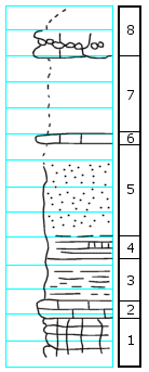
KGS Home

Geology Index Page

Wabaunsee County

Sec. 11, T. 13 S., R. 12 E
Move to another county

0.4 mi. S of NE corner of section
Measured By Swain, August 29, 1940
Unit No. Description Thickness
- Concealed above  
8 Limestone, thin-bedded, cavernous, brecciated 2-3 ft.
7 Concealed 6.0 ft.
6 Limestone in ditch, argillaceous, sandy with brachiopods, echinoid spines 0.5 ft.
5 Sandstone, cross-bedded, micaceous, top concealed 12.0 ft.
4 Shale, green, very limy and boxwork, poorly exposed 2.0 ft.
3 Shale, purple and green 3.0 ft.
2 Limestone, rubbly 1.0 ft.
1 Boxwork, laminated, very argillaceous limestone 3.0 + ft.

Original Document

The Archive file you download contains a TIFF image compressed into a ZIP archive. Your browser may be already set up to decompress these files. Commercial software to perform this is available from PKWARE, Inc., the company that invented the format. A web page from a group of people creating shareware or public domain software is available at Info-ZIP. The TIFFs are 150-dpi archival-quality color scans of the original forms and can be viewed by software like Corel PhotoPaint or Adobe PhotoShop.


Kansas Geological Survey
Comments to webadmin@kgs.ku.edu
URL=http://www.kgs.ku.edu/General/Geology/Measured/index.html
Programs Updated May 2003