|
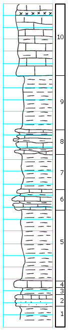
| Unit No. |
Description |
Thickness |
|
10
|
Limestone, light gray, weathers yellow-green, soft, impure, medium bedded, upper part sandy and unfossiliferous, lower part has (a) Triticites; has celestite or gypsum zone at top
|
12.0 ft.
|
|
9
|
Shale, bluish to dark, hard and soft
|
8.5 ft.
|
|
8
|
Limestone and shale interbedded grades into adjacent beds within sharp boundaries
|
4.0 ft.
|
|
7
|
Shale, bluish, calcareous cont. (a) Triticites
|
5.5 ft.
|
|
6
|
Limestone and shale like 8
|
3.5 ft.
|
|
5
|
Shale, blue-green (a) brachiopods, bryozoans, etc.
|
12.0 ft.
|
|
4
|
Limestone, light green, fine grained, a single massive bed, hard, contains crinoid stems, a few brachiopods and scattered Triticites
|
1.2 ft.
|
|
3
|
Shale, dark blue, drab weathers with yellow blotches, clayey, soft
|
1.2 ft.
|
|
2
|
Limestone, like 4, but in thin beds and less fossiliferous
|
1.8 ft.
|
|
1
|
Shale, dark blue, clayey
|
2 + ft.
|
|

