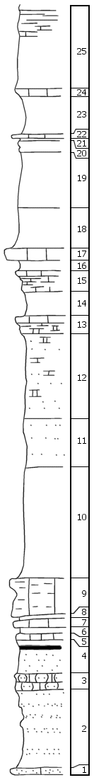
| Unit No. |
Description |
Thickness |
|
|
Hughes Creek Shale Member
|
|
|
25
|
Upper part limy platy fossiliferous shale, contains brachiopods and bryozoans; lower part green-gray and gray platy shale; Lower 5' contains fusulinids, etc.
|
9.5 ft.
|
|
24
|
Soft gray limestone, molluscan and brachiopod fauna
|
1 ft.
|
|
23
|
Gray limy fossiliferous shale, fusulinids
|
4.5 ft.
|
|
22
|
Hard gray fossiliferous limestone
|
0.5 ft.
|
|
21
|
Green-gray shale
|
0.5 ft.
|
|
20
|
Impervious shaly limestone, nodular, fossiliferous, gray
|
1 ft.
|
|
19
|
Green-gray shale, covered with fusulinids but none found in place
|
7 ft.
|
|
18
|
Limy gray fossiliferous shale, abundant bryozoans and brachiopods
|
5 ft.
|
|
|
Americus Limestone Member (units 17-13)
|
|
|
17
|
Massive gray limestone bed
|
1.2 ft.
|
|
16
|
Green-gray fossiliferous shale
|
1.5 ft.
|
|
15
|
Limestone and shale up 0.8' limestone bed, 0.3' gray fossiliferous shale, 0.9' broken gray limestone
|
2 ft.
|
|
14
|
Green-gray shale
|
3 ft.
|
|
13
|
1' gray limestone, 1' spongy brown limy material
|
2 ft.
|
|
12
|
Green-gray sandy limy shale
|
10 ft.
|
|
11
|
Sandy platy yellow brown gr shale
|
6 ft.
|
|
10
|
Covered
|
0.3 ft.
|
|
|
Five Point Limestone Member (units 9-5)
|
|
|
9
|
Massive, gray, coquinoid, porous limestone
|
4.5 ft.
|
|
8
|
Brown-yellow clay shale
|
0.4 ft.
|
|
7
|
Fossiliferous gr limestone, abundant crinoids, brachiopods
|
0.9 ft.
|
|
6
|
Gr fossiliferous shale, Chonetes etc. and bryozoans
|
1 ft.
|
|
5
|
Fossiliferous limestone; fusulinids, crinoids, brachiopods, bryozoans
|
0.5 ft.
|
|
4
|
0.8' yellow gr shale; 0.2' coal; 3' platy, yellow gr sandy shale
|
4 ft.
|
|
3
|
Nodular sandy impervious limestone
|
2 ft.
|
|
2
|
Sandy shale and sandstone, gray to yellow-brown, platy
|
9 ft.
|
|
1
|
Gr micaceous sandstone
|
1 ft.
|