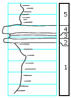
KGS Home

Geology Index Page

Wabaunsee County

Sec. 13, T. 13 S., R. 12 E
Move to another county

In pasture S of road
Measured By H.G. O'Connor, J.M. Jewett, 1952
Unit No. Description Thickness
5 Shale, gray and green, limy nodules, deeply weathered, exposed 2.0 +/- ft.
4 Limestone, purplish-brown, forams? (Bed 4 in NE 10-12-10E) 0.8 +/- ft.
3 Shale, gray 0.2 ft.
2 Limestone, brown, crystalline 0.4 ? ft.
1 Shale, yellowish-gray, non-fossiliferous, deeply weathered, exposed 4.0 +/- ft.

Original Document

The Archive file you download contains a TIFF image compressed into a ZIP archive. Your browser may be already set up to decompress these files. Commercial software to perform this is available from PKWARE, Inc., the company that invented the format. A web page from a group of people creating shareware or public domain software is available at Info-ZIP. The TIFFs are 150-dpi archival-quality color scans of the original forms and can be viewed by software like Corel PhotoPaint or Adobe PhotoShop.


Kansas Geological Survey
Comments to webadmin@kgs.ku.edu
URL=http://www.kgs.ku.edu/General/Geology/Measured/index.html
Programs Updated May 2003