|
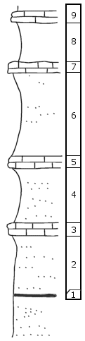
| Unit No. |
Description |
Thickness |
|
9
|
Fine brown limestone, conglomeratic, brecciated or algal appearance; equals bed 13 of R-118
|
1 ft.
|
|
8
|
Shale, covered
|
5 ft.
|
|
7
|
Granular brown speckled laminated limestone, equals bed 11 of R-118
|
1 ft.
|
|
6
|
Shale, upper part is yelh gr platy sdy, lower is green-gray clay shale
|
10 ft.
|
|
5
|
Brownville, fossil fragments and M. splendens
|
1.5 ft.
|
|
4
|
Shale, upper 1.5' is green-gray and contains Chonetes at top, rest is sandy shale weathering yelh
|
6.5 ft.
|
|
3
|
Granular to coquinoid limestone, fresh is dark blh gray, weathers yelh brown, contains large, flat pelecypods, Myalina, etc.
|
1.5 ft.
|
|
2
|
Sandy gray shale, weathers yelh, platy, green at top
|
7 ft.
|
|
1
|
Coal
|
0.15 ft.
|
|
-
|
Sandy shale below this
|
|
|

