|
| Unit No. |
Description |
Thickness |
|
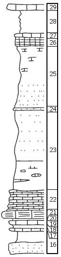
29
|
Hard massive light-gray limestone bed, fossiliferous, some fusulinids, weathers into large slabs 4' x 6' x 1' large
|
1 ft.
|
|
28
|
Covered
|
4 ft.
|
|
27
|
Soft gray limestone
|
0.5 ft.
|
|
26
|
Nodular, sandy, limy "boxwork," yellow-brown
|
1.5 ft.
|
|
25
|
Upper part platy, green-gray shale, lower 4' +/- very sandy yellow brown gray shale
|
11 ft.
|
|
24
|
Brown granular conglomerated sandy limestone
|
0.3 ft.
|
|
23
|
Sandy green-gray shale, no fossils seen; lower 5' green-gray nodular limy shale, no fossils seen
|
13 ft.
|
|
22
|
Slabby soft light gray to cream limestone, 0.2' green shale at bottom
|
3 ft.
|
|
21
|
Granular crystalline massive limestone, fossiliferous, weathers out like Americus, only lith diff
|
1.2 ft.
|
|
20
|
Dark gray limestone
|
0.2 ft.
|
|
19
|
Gray fossiliferous limestone, Chonetes, few bryozoans, corals
|
0.7 ft.
|
|
18
|
Dark gray limy shale, fossiliferous
|
0.8 ft.
|
|
17
|
Nodular limy bed
|
0.3 ft.
|
|
16
|
Upper 2' gray clay shale, lower 2' gray massive sandstone, large plant impressions
|
4 +/- ft.
|
|

