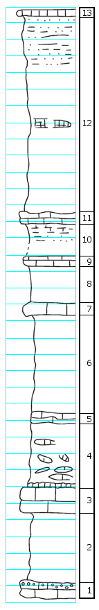
|
| Unit No. |
Description |
Thickness |
|
13
|
Limestone slabs strewn in road; 6" massive, brown sugary texture (Falls City Limestone)
|
|
|
12
|
Shale, mostly concealed, 10' +/- above limestone below 1-2' of boxwork; upper 6' sandy shale and fine-grained, thin-bedded sandstone, rust brown (Hawxby Shale Member)
|
24.0 ft.
|
|
11
|
Limestone, gray, weathers brown, thin-bedded, argillaceous... [Continued; see archive file for complete description]
|
1.0 ft.
|
|
10
|
Shale, brown, clayey, covered at base, chalk nodules
|
3.4 ft.
|
|
9
|
Limestone, thin-bedded, slabby, packed with mollusks, small clams, and snails, some Pectens
|
1 +/- ft.
|
|
8
|
Covered
|
4.0 ft.
|
|
7
|
Limestone, medium-gray, dense, massive, weathers light gray, echinoid spines (Aspinwall Limestone Member)
|
1.0 +/- ft.
|
|
6
|
Covered slope, shale?; slabs like below in lower part (Towle Shale Member)
|
15.5 ft.
|
|
5
|
Shale, slope strewn with slabs of sandstone conglomerate and molluscan limestone
|
8.5 ft.
|
|
4
|
Coarse sandstone or conglomerate
|
< 1 ft.
|
|
3
|
Brownville Limestone Member, rust-brown, argillaceous, rubbly limestone, Punctospirifer, crinoid stems, type C, Chonetina, Lophophyllum, fusulines, Marginifera, Dictyoclostus, Pectinoids
|
3.0 ft.
|
|
2
|
Covered, some clay shale exposed below Brownville (Pony Creek Shale Member)
|
8.0 ft.
|
|
1
|
Limestone, light gray conglomeratic on top (limestone conglomerate), fragments of brown limestone and clay shale, bryozoans, brachiopods and other mascerated bed remains (Caneyville)
|
1.0 ft.
|
|

