|
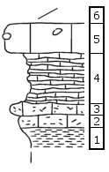
| Unit No. |
Description |
Thickness |
|
6
|
Covered
|
|
|
5
|
Crinoid wackestone, gray, with few brachiopods and 10-cm-diameter pink geodes of quartz and calcite
|
0.25 m
|
|
4
|
Shaly, foram wackestone to resistant, calcareous shale, gray
|
0.4 m
|
|
3
|
Peloid, intraclast grainstone to packstone, tan, with fine-sand-sized micritic peloids about 40%, intraclasts about 4%, and fine-sand quartz grains about 2% of rock, few loose Calcivertella forams, rare ostracodes, and very rare tiny bivalve fragments and loose Spirorbis worm tubes... [Continued; See archive file for complete description]
|
0.1 m
|
|
2
|
Peloid, intraclast, quartz-sand wackestone, yellow, with fine-sand-sized micritic peloids about 25%, very-fine-sand-sized quartz grains about 5%, and intraclasts of peloid, alga boundstone about 5% of rock, common Calcivertella forams (some encrusted on micritic peloids) and ostracodes... [Continued; See archive file for complete description]
|
0.1 m
|
|
1
|
Shale, yellow
|
|
|
