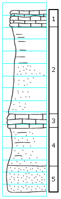
Coal dump (shaft) in NE 1/4. Outcrop of rock S side of road and stream bank. 0.4 mi. W of NE corner of section. 4 mi. N, 1 1/2 mi. W of Harveyville
Measured By W.H. Schoewe, Oct. 26, 1944
[See archive file for additional notes and diagrams]
Unit No.
Description
Thickness
1
Limestone, fossiliferous, thin slabs
1.5 ft.
2
Shale, tan-buff, limy, fossils, lower part bedded sandstone
The Archive file you download contains a TIFF image compressed into a ZIP archive.
Your browser may be already set up to decompress these files.
Commercial software to perform this is available from
PKWARE, Inc., the company that invented the format.
A web page from a group of people creating shareware or public
domain software is available at Info-ZIP.
The TIFFs are 150-dpi archival-quality color scans of the original forms and can be viewed by software like Corel PhotoPaint or Adobe PhotoShop.
Kansas Geological Survey
Comments to webadmin@kgs.ku.edu
URL=http://www.kgs.ku.edu/General/Geology/Measured/index.html
Programs Updated May 2003