|
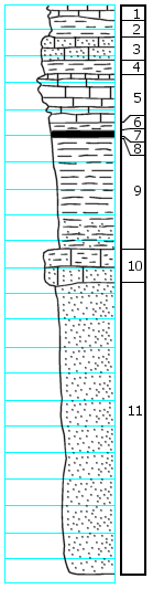
| Unit No. |
Description |
Thickness |
|
1
|
Limestone, green-gray, weathers yellow-brown to nearly white; impure silty, massive, grades into below
|
0.7 ft.
|
|
2
|
Shale, green, calcareous, medium-bedded, some yellow-brown in lower part, mostly covered
|
1.0 +/- ft.
|
|
3
|
Limestone, tan to tan-gray, weathers nearly white, fairly hard, massive, sandy
|
0.9 +/- ft.
|
|
4
|
Shale, yellow-brown with some blue-gray, calcareous, thin-bedded
|
0.5 +/- ft.
|
|
5
|
Limestone, blue-gray, weathers light yellow-brown, fairly hard; fusulines, brachiopod fragments, Hustedia, Chonetes, Dictyoclostus, crinoid stems; top part rather shelly with shale partings with the lower part rather massive
|
1.7 +/- ft.
|
|
6
|
Shale, yellow-brown
|
0.3 ft.
|
|
7
|
Coal
|
0.2 ft.
|
|
8
|
Underclay
|
0.1 ft.
|
|
9
|
Shale, yellow-brown and blue-gray, becomes more yellow-brown and sandy in lower part
|
4.0 ft.
|
|
10
|
Limestone, gray to blue-gray, weathers yellow-brown, shaly, fairly soft, massive, grades into below; Aviculopecten, Marginifera, brachiopod fragments, bryozoans, crinoid stems, Myalina, Dictyoclostus
|
1.5 ft.
|
|
11
|
Sandstone, yellow-brown, micaceous, poorly cemented
|
11.0 ft.
|
|

