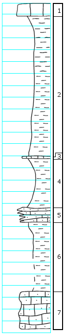
KGS Home

Geology Index Page

Wabaunsee County

Sec. 15, T. 15 S., R. 13 E
Move to another county

Along creek 1/6 mile south of center of north side of section 15
Measured By H.G. O'Connor, Oct. 15, 1949
Remarks: Hand leveled and direct measured section. Intervals not exact. [See archive file for additional notes]
Unit No. Description Thickness
1 Limestone, gray with purple-red top, weathers shelly and in large joint blocks. Contains fusulines, crinoids, Chonetes and other brachiopods and Cryptozoan algae 1.0 ft.
2 Shale, gray, carbonaceous at top, sandy to argillaceous in lower part 12.0 ft.
3 Concretion of limestone or limy shale, contains crinoids, snails, clams, and bryozoans 0.1 +/- ft.
4 Shale, gray to tan 4.5 +/- ft.
5 Limestone, gray, shaly, impure, contains snails, clams, and crinoid fragments 1.0 ft.
6 Shale, mostly poorly exposed 6.0 +/- ft.
7 Limestone, gray to brown, sandy appearing. Fossil material not identified, much of it may be algal? No fusulines present, few clams and snails; Myalina, Bellerophon 3.0 +/- ft.

Original Document

The Archive file you download contains a TIFF image compressed into a ZIP archive. Your browser may be already set up to decompress these files. Commercial software to perform this is available from PKWARE, Inc., the company that invented the format. A web page from a group of people creating shareware or public domain software is available at Info-ZIP. The TIFFs are 150-dpi archival-quality color scans of the original forms and can be viewed by software like Corel PhotoPaint or Adobe PhotoShop.


Kansas Geological Survey
Comments to webadmin@kgs.ku.edu
URL=http://www.kgs.ku.edu/General/Geology/Measured/index.html
Programs Updated May 2003