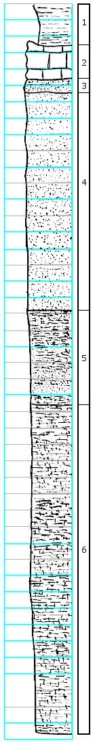
KGS Home

Geology Index Page

Wabaunsee County

Sec. 10, T. 15 S., R. 13 E
Move to another county

On road between sections 10 and 15 in the SE 1/4 of sec. 10, down ditch in pasture
Measured By R.E. O'Connor, July 23, 1950
Remarks: Photo 70-A-14 (Hand Leveled)
Unit No. Description Thickness
1 Shale, bluish-gray, calcareous, caliche-like nodules weathering out of it 2.5 ft.
2 Limestone, gray, weathers brownish-gray with yellow-brown, very uneven top, solution channeled; contains Cryptozoan algae, horn coral, fusulines, (large-weather out all over the ground), crinoid stems, brachiopod fragments 2.0 +/- ft.
3 Sandstone, gray and yellow-brown, hard, well cemented, calcareous, grades into loose sand below 0.85 ft.
4 Sandstone, yellow-brown and gray, loose, sandstone, platelets throughout, micaceous 13.4 ft.
5 Sandstone and shale, gray shale and yellow-brown sandstone, poorly bedded; grades into below 5.7 ft.
6 Shale, gray, very sandy and micaceous 20.0 +/- ft.

Original Document

The Archive file you download contains a TIFF image compressed into a ZIP archive. Your browser may be already set up to decompress these files. Commercial software to perform this is available from PKWARE, Inc., the company that invented the format. A web page from a group of people creating shareware or public domain software is available at Info-ZIP. The TIFFs are 150-dpi archival-quality color scans of the original forms and can be viewed by software like Corel PhotoPaint or Adobe PhotoShop.


Kansas Geological Survey
Comments to webadmin@kgs.ku.edu
URL=http://www.kgs.ku.edu/General/Geology/Measured/index.html
Programs Updated May 2003