|
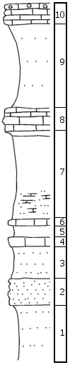
| Unit No. |
Description |
Thickness |
|
10
|
Limestone, conglomeratic at top, spongy, lower part is yellow-gray, mealy
|
2.5 +/- ft.
|
|
9
|
Yellow-gray, slightly sandy shale, may have maroon streak near top, partly covered
|
10 ft.
|
|
8
|
Limestone, light gray at top, brown, impervious, nodular, fossiliferous
|
2.5 ft.
|
|
7
|
Upper part gray to yellow-gray, partly covered, contains red-hued streak near top; lower part platy, limy, and sandy shale, yellow-brown; middle partly covered
|
10.5 ft.
|
|
6
|
Dense to mealy limestone (Base of Dover is 64') below this bed in sec. 30-11-13
|
0.5 ft.
|
|
5
|
Dark gray shale, greenish yellow-gray
|
1.5 ft.
|
|
4
|
Impervious gray limestone
|
1 ft.
|
|
3
|
Sandy gray to platy yellow-brown shale
|
4 ft.
|
|
2
|
Soft gray sandstone
|
3 ft.
|
|
1
|
Platy, sandy, yellow-gray-brown shale (covered below)
|
6 +/- ft.
|
|

