|
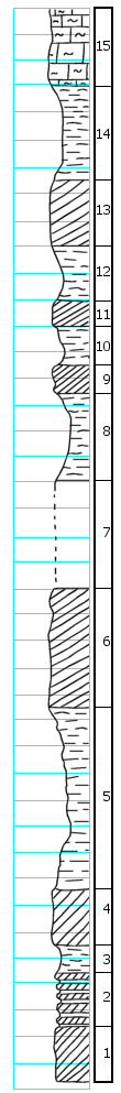
| Unit No. |
Description |
Thickness |
|
15
|
Limestone (or siltstone) grading into overlying soil
|
2.0 ft.
|
|
14
|
Shale, varicolored
|
3.5 ft.
|
|
13
|
Gypsum, red and blue
|
2.0 ft.
|
|
12
|
Shale, blue
|
2.0 ft.
|
|
11
|
Gypsum, red and blue
|
1.0 ft.
|
|
10
|
Shale, gray
|
1.5 ft.
|
|
9
|
Gypsum, massive, white
|
1.0 ft.
|
|
8
|
Shale, blue and gray
|
3.5 ft.
|
|
7
|
Covered interval
|
4.0 ft.
|
|
6
|
Gypsum, white, massive, with large (1/2") selenite crystals
|
4.5 ft.
|
|
5
|
Shale, gray-green, beds of satinspar paralleling and cutting the shale bedding
|
7.0 ft.
|
|
4
|
Gypsum, white and yellowish-white, with black selenite crystals (average)
|
2.0 ft.
|
|
3
|
Shale, gray-green
|
1.1 ft.
|
|
2
|
Alternating bands of black gypsum and shale. At the top of the sequence is a 0.2' bed of white gypsum
|
2.0 ft.
|
|
1
|
Gypsum, black to gray, banded
|
2.0 ft.
|
|