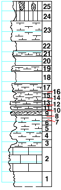
|
| Unit No. |
Description |
Thickness |
|
|
Holmesville shale formation
|
|
|
25
|
Shale, greenish, with vertical bands of maroon
|
2 ft.
|
|
24
|
Shale, greenish to yellow-brown
|
2 ft.
|
|
23
|
Mudstone to box-work, very calcareous, rusty, brownish-yellow
|
4 ft.
|
|
22
|
Shale, calcareous, light-gray
|
2 ft.
|
|
21
|
Mudstone, light-gray, soft
|
1 ft.
|
|
20
|
Shale, calcareous, light-gray
|
2 ft.
|
|
19
|
Mudstone, light-gray, soft
|
1 ft.
|
|
18
|
Shale, calcareous, light-gray
|
2.5 ft.
|
|
17
|
Mudstone, soft, splittery, light-gray
|
1.5 ft.
|
|
16
|
Shale, calcareous, light-gray
|
0.5 ft.
|
|
15
|
Mudstone, soft, light-gray
|
0.7 ft.
|
|
14
|
Shale, calcareous, light-gray
|
0.8 ft.
|
|
13
|
Mudstone, light-gray
|
0.7 ft.
|
|
12
|
Shale, light-gray
|
0.1 ft.
|
|
11
|
Mudstone, light-gray
|
0.5 ft.
|
|
10
|
Shale, light-gray
|
0.1 ft.
|
|
9
|
Mudstone, with a flint band, very fossiliferous with pelecypods and Bellerophon
|
0.8 ft.
|
|
8
|
Shale, light-gray
|
0.5 ft.
|
|
7
|
Mudstone, soft
|
0.6 ft.
|
|
6
|
Shale, calcareous
|
0.8 ft.
|
|
5
|
Mudstone, soft
|
1.2 ft.
|
|
4
|
Shale, calcareous
|
1.5 ft.
|
|
3
|
Mudstone, soft
|
1.5 ft.
|
|
|
Fort Riley limestone member
|
|
|
2
|
Mudstone, massive, with large caverns
|
5 ft.
|
|
1
|
Shale, gray, with small Derbyia, bryoza, Dictyoclostus americanus, and other fossils
|
3 ft.
|
|

