|
| Unit No. |
Description |
Thickness |
|
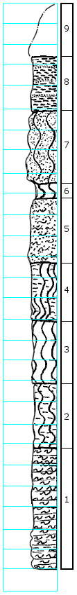
9
|
Residual, contains chunks of sandstone
|
2.6 ft.
|
|
8
|
Shale, gray with horizontal thin yellow sandstone bands, contains gypsum
|
2.7 ft.
|
|
7
|
Clay, very sandy, sand is yellow, clay is gray, more sand toward bottom, gypsum in bottom, band of concretionary hematite
|
3.6 ft.
|
|
6
|
Clay, silty, gray
|
0.8 ft.
|
|
5
|
Sandstone to silt, gray and yellow, fine
|
0.8 ft.
|
|
-
|
Unconformity
|
|
|
4
|
Clay and shale, gray, silty, thin bedded; sulfur yellow in horizontal joints
|
2.6 ft.
|
|
3
|
Clay, shaley, dark gray, sulfur yellow in joints, gypsum present
|
3.3 ft.
|
|
2
|
Clay and shale, silty, dark gray, yellow banded 0.5' at top and a narrow one 0.6' from bottom
|
3.0 ft.
|
|
1
|
Silt, clayey, gray, horizontally bedded, some shale streaks toward bottom and top; slight yellow in center
|
5.8 ft.
|
|