|
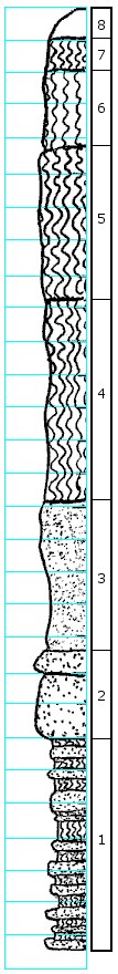
| Unit No. |
Description |
Thickness |
|
8
|
Covered
|
0.8 ft.
|
|
7
|
Clay, gray and brownish, with balls or pellets of limonite
|
1.0 ft.
|
|
6
|
Clay, gray, plastic, with yellow stain, soil and roots from surface, probably similar to beds 4 and 5
|
2.25 ft.
|
|
5
|
Clay, gray, smooth, plastic, slight yellow stain in joints, a yellow streak at top and 6.25' from top; kaolin streak 4.6' from top; leaf fossils
|
6.5 ft.
|
|
4
|
Clay, gray, plastic to slightly sandy, with very slight yellow stain, pink streak at top (lignitic)
|
4.0 ft.
|
|
3
|
Sandstone, partly clayey, some yellow stain, vertical limonite concretions
|
5.6 ft.
|
|
2
|
Sandstone, massive
|
2.0 ft.
|
|
1
|
Clay, sandy and sandstone, clayey, obliquely, roughly interbedded, probably interfingering or lenticular, gray, with limonitic yellow, one limonite concretion with hematite inside
|
6.0 ft.
|
|