|
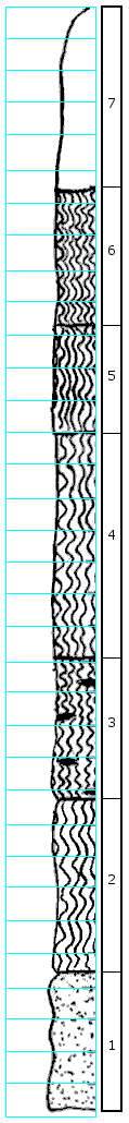
| Unit No. |
Description |
Thickness |
|
7
|
Covered, residual clay and sand, contains fragments of red-brown sandstone
|
5.5 ft.
|
|
6
|
Clay, light gray, plastic with yellow and some red mottling, some granular hematite and limonite, contains sandy patches
|
4.3 ft.
|
|
5
|
Clay, yellow and gray, very sandy, some dark red stain
|
3.3 ft.
|
|
4
|
Clay, light gray, mostly plastic, with slight yellow stain, more in bottom 3' than top, contains plant fossils and dendritic kaolin at base, very thin
|
7.1 ft.
|
|
3
|
Clay, gray and yellow-orange, plastic, yellow-orange in small lenticular streaks, slight amount granular, limonite
|
4.7 ft.
|
|
2
|
Clay, gray, mostly plastic with very slight yellow stain, more silty toward bottom, dendritic black and lignite
|
5.5 ft.
|
|
1
|
Sandstone, gray, clayey, with some yellow stain
|
4.1 ft.
|
|