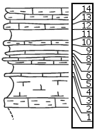
KGS Home

Geology Index Page

Saline County

Sec. 25, T. 16 S., R. 1 W
Move to another county

6 mi. N, 2 mi. E of Roxbury (McPherson Co.), NE corner
Unit No. Description Thickness
14 Shale ... splittery mudstone, interbedded 1.5 ft.
13 Shale 0.5 ft.
12 Mudstone, splittery 0.5 ft.
11 Shale 1.5 ft.
10 Mudstone, splittery 0.5 ft.
9 Shale 1.4 ft.
8 Mudstone 0.2 ft.
7 Shale 0.4 ft.
6 Limestone, tough, with Estheria and broken fish scales 0.2 ft.
5 Mudstone, splittery 0.3 ft.
4 Shale, soft, gray, splittery 1.5 ft.
3 Limestone, tough, with Estheria 0.2 ft.
2 Shale, splittery, gray calcareous to mudstone 2.8 ft.
1 Mudstone, splittery 1 ft.

Original Document

The Archive file you download contains a TIFF image compressed into a ZIP archive. Your browser may be already set up to decompress these files. Commercial software to perform this is available from PKWARE, Inc., the company that invented the format. A web page from a group of people creating shareware or public domain software is available at Info-ZIP. The TIFFs are 150-dpi archival-quality color scans of the original forms and can be viewed by software like Corel PhotoPaint or Adobe PhotoShop.


Kansas Geological Survey
Comments to webadmin@kgs.ku.edu
URL=http://www.kgs.ku.edu/General/Geology/Measured/index.html
Programs Updated May 2003