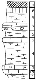
KGS Home

Geology Index Page

Dickinson County

Sec. 12, T. 11 S., R. 2 E
Move to another county

W center NW 1/4 of section
Measured By M.K. Elias, 1932
Remarks: V-12
Unit No. Description Thickness
  Odell Shale Member  
10 Shale, red 1.5 ft.
9 Shale, green 1.5 ft.
8 Mudstone, white, splittery, with zone of quartz geodes below the middle and with Orbiculoidea in one half 3 ft.
7 Limestone, flaggy at the top; zone of flint nodules near the base; with Pleurophorus and Murchisonia 2 ft.
  Cresswell Limestone Member  
6 Mudstone, splittery 2 ft.
5 Mudstone 1 ft.
4 Mudstone, splittery, few echinoid remains in one part 6.5 ft.
3 Limestone, massive, geodes near the top; few echinoid remains 2 ft.
2 Mudstone, splittery 0.5 ft.
1 Shale, calcareous, with Derbya in one part 1 ft.

Original Document

The Archive file you download contains a TIFF image compressed into a ZIP archive. Your browser may be already set up to decompress these files. Commercial software to perform this is available from PKWARE, Inc., the company that invented the format. A web page from a group of people creating shareware or public domain software is available at Info-ZIP. The TIFFs are 150-dpi archival-quality color scans of the original forms and can be viewed by software like Corel PhotoPaint or Adobe PhotoShop. To read the PDF version, you will need the Acrobat PDF Reader, available free from Adobe.


Kansas Geological Survey
Comments to webadmin@kgs.ku.edu
URL=http://www.kgs.ku.edu/General/Geology/Measured/index.html
Programs Updated May 2003