|
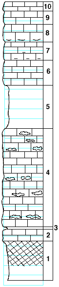
| Unit No. |
Description |
Thickness |
|
10
|
Limestone, thin bedded, disintegrated
|
2 ft.
|
|
9
|
Limestone, brownish, with fragments of pelecypods
|
2.5 ft.
|
|
8
|
Limestone, thin bedded, light color grading into shale
|
3.75 ft.
|
|
7
|
Limestone, cellular, with iron streaks and stem-like marks
|
3.75 ft.
|
|
6
|
Limestone, cellular
|
5 ft.
|
|
5
|
Marls and clayey shale with brachiopods and bryozoans
|
9 ft.
|
|
4
|
Limestones with layers of chert and chert concretions, including a two-foot layer of soft limestone below the chert. Aviculipinna at the top of the flint
|
2 ft.
|
|
3
|
Shale, soft, gray and fossiliferous
|
0.5 ft.
|
|
2
|
Limestone
|
2.5 ft.
|
|
1
|
Shale, red and black, carbon in places, with plants
|
8 ft.
|
|
